


How GPS Tracker Works and Cell Phone Tower Triangulation Accuracy
There are 3 methods for pinpointing the location of Tracki GPS tracker using geo-location data.
1. Global Positioning System (GPS) capability, use signals from satellites to pinpoint location very accurately.
2. Wi-Fi by tracking routers MAC ID. If Tracki GPS tracker can't find a GPS signal it will listen to all the WiFi routers around and report their MAC ID to our servers which have access to a mapping of worldwide WiFi routers and their location, accuracy is about 100-300 feet.
3. The less-accurate method is often called “Cell Tower Triangulation”, referring to how the cell towers calculate the tracker’s geophysical location.
What is Cell Tower Triangulation?
In an ideal scenario, the GPS tracker’s signal may be picked up by 3 or more cell towers, enabling the triangulation to work. From a mathematical standpoint, if you have the distance to a location from each of three distinct points, you can compute the approximate location of that location in relation to the three reference points. At Tracki since we access to mapping of all cellular towers location worldwide, we know the locations of the cell towers which receive our GSM signal, and we can estimate the distance of the GPS tracker from each of those antenna towers, based upon the lag time between when the tower sends a ping to Tracki GPS tracker and receives the answering ping back.
In some cases, there actually may be more than three cell towers receiving a GPS tracker's signal, allowing for even better accuracy. In major metropolitan urban areas, the accuracy of GPS tracker pinpointing is relatively high because there are usually more cell towers with their signal coverage areas overlapping. In cases where the GPS tracker is not exposed to the open sky being inside buildings or underground, in case there are no Wi-Fi routers around, cell tower triangulation may be the only location finding way since GPS signal is not available.
However, there are many places where there are fewer cell towers available, such as in the outskirts of the cities and out in the country. If you have fewer than three cell towers available, pinpointing a GPS tracking device can become a lot less accurate. In cities where there are a lot more vertical structures which can be barriers to GPS tracker broadcasting and receiving, there have to be many more cell towers distributed in order to have good service. In the countryside, there are relatively fewer cell towers and a GPS tracker's signal may be picked up only by only one tower at much greater distance.
Those areas where the GPS tracker is only getting picked up by a single tower, and if it’s equipped with only single omnidirectional antenna, the accuracy becomes even less.
In rural areas tracking accuracy can vary from 0.25 mile to several miles, depending upon how many obstacles could be blocking the tower’s signal.
How GPS tracker works?
GPS, or global positioning system makes use of 24 to 32 solar-powered satellites and their ground stations to transmit information to GPS-enabled.
The main idea of GPS systems is to determine the location of a certain object or person in real time. GPS tracking systems utilize the global navigation satellite system (GNSS) network. Each of these satellites in orbit sends microwave signals to a receiver. The receiver inside the GPS tracker then uses these signals to calculate your precise location from at least four of the GPS satellites. Finally, your location is determined once the system triangulates your exact position on the planet to the nearest meters based on these distances.
The process follows a simple mathematical principle called trilateration. To complete the mathematical calculation, GPS receivers uses the accurate position of at least 4 satellites and the distance to each to estimate 4 values: earth latitude, earth longitude, elevation and time. The position and distances to a given satellite determines the position of the receiver. The accurate position of a satellite is repeatedly transmitted to all receivers in line of sight and usually require open sky. The distance to a satellite is found by the precise time the satellite transmission arrives at the receiver. The time generated each satellite’s atomic clock is transmitted by the satellite at preset intervals.
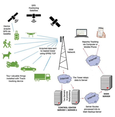
How a GPS Tracking Device Works
GPS tracking devices work on the same principle, but instead of displaying information on the device itself, the microprocessor on the device will calculate its location and transmit the concluded data to a server over the Internet using worldwide GSM cellular network. That server hosts a platform that end users can access and view the device’s current and past historical path, speed and alerts. All this data is then served via the internet and displayed on an end user device using a desktop app or to a smart phone using iPhone or Android app.
A GPS tracking system can benefit anyone. For business owners, it can be used for fleet monitoring, the behaviour of employees, for families to keep track of elderly, children or pets. Travelers place a GPS tracker in their luggage to prevent it from getting lost or stolen.
Active trackers, on the other hand, process and deliver data in real time using a SIM and a GSM transceiver. Dispatchers receive real-time information via the GSM cellular network allowing them to closely monitor their assets or precious things. Monthly fees are charged to pay for the cellular network services.
In case that the GPS satellites signal is blocked being indoor or by a structure, since there is no sky, not allowing for the GPS satellites signal to get through, the device is looking for cell tower signals and by cell tower signal strength triangulation trying to estimate rough location.
The GPS tracker determine where the device is located and roughly estimate the distance between the cell phone towers by interpolating signals between adjacent towers. A precision of down to 300 feet may be obtained in urban areas where density of cell phone towers is very high. Rural and county side areas which has less towers per square mile may see many miles between base stations and therefore inaccurately determine locations often showing a location miles away from the device real location.
Conclusion
when GPS satellite signal is available that is preferable to use. But in those cases when a GPS tracking device is blocked from open sky by structures, tall buildings, trees or even heavy clouds, cell tower approximation can mean the difference between knowing a general area whereabouts of GPS tracker or being in a complete dark.